Trail Map - click map for larger or - Trail Map Download
Location
Billinge Hill is a tree topped mound overlooking Blackburn and towards Preston about the same size as Healey Nab much
less than a mile square. Once the home and garden of landed gentry it was given to the town to be managed by the local
council, as it remains today.
Development of Mountainbiking on Billinge Hill.
Billinge Hill has been used for off-road riding for many years since the use of mountainbikes was popularised back in the
1990’s. There has been access from Under Billinge Lane onto concessionary bridleway which skirts the hill and finally
joins a wide track that can also be accessed from Billinge End Road, and then leads to the summit. These trails are of a
medium gradient often covered in leaves, slippery, sometimes soggy at ditch crossings but with very little punctuation
with features of interest to mountainbikers. This led riders to develop and use side trails. When the council wanted to
develop Witton park as a general centre for activity and exercise, back in 2007 the trails in use by Blackburn and District
Mountainbikers on Billinge Hill were shown to the council and the general route of one became the Tricky 60 and
another the Two trees. The actual landscape routing, features and detail were developed by a skilled contractor Phil
Saxena and his company Architrail who worked with a local contractor to first cut and then sculpt the shape of the
berms and flowing lines to be a good riding experience. The rhododendrons were removed then foundation formed
using undersoil from borrow pits. Rock features were exposed, Large individual rocks so uncovered were moved into the
line of the trail and even the mature trees were used as bridge supports to add interest and fun to the riding
experience..
Parking
It was originally envisaged visitors might park on the little park on Killiard Lane off Billinge End Road near to the Clog and
Billycock, unfortunately antisocial behaviours caused some public concern and access to parking there has been denied
for 5 years or so.. Access is therefore recommended by parking in one of the Witton Park carparks. The main car park
BB2 1TP, and also from Tower Road towards the Crematorium BB2 5LE there are further parking opportunities giving
access to feeder trails.
Access
Leaving the perimeter track west of the Pavillion, there is a bridleway heading up through Crow Wood to Under Billinge
Lane. Some of this trail has been “sanitised” but much is left natural, with loads of roots to negotiate and muddy
patches to cross. In places it’s also quite steep and there are a few gates to pass through. This stage has been signed
towards the Billinge Hill Trails but these signs often do not survive public attention. Worth noting this is a shared trail
and descending riders might be seen as unfriendly by other users if overly exhuberant.
As you climb steeply to exit Crow Wood cross Under Billinge Lane, passing through the archway and into the woodland
following the signs to the trail head. There are many trails heading up, signing might not survive, some more ridable
than others that might prove a challenge. The trail head is pretty much at the highest point where you will find the
original gun turret that stood over Blackburn.
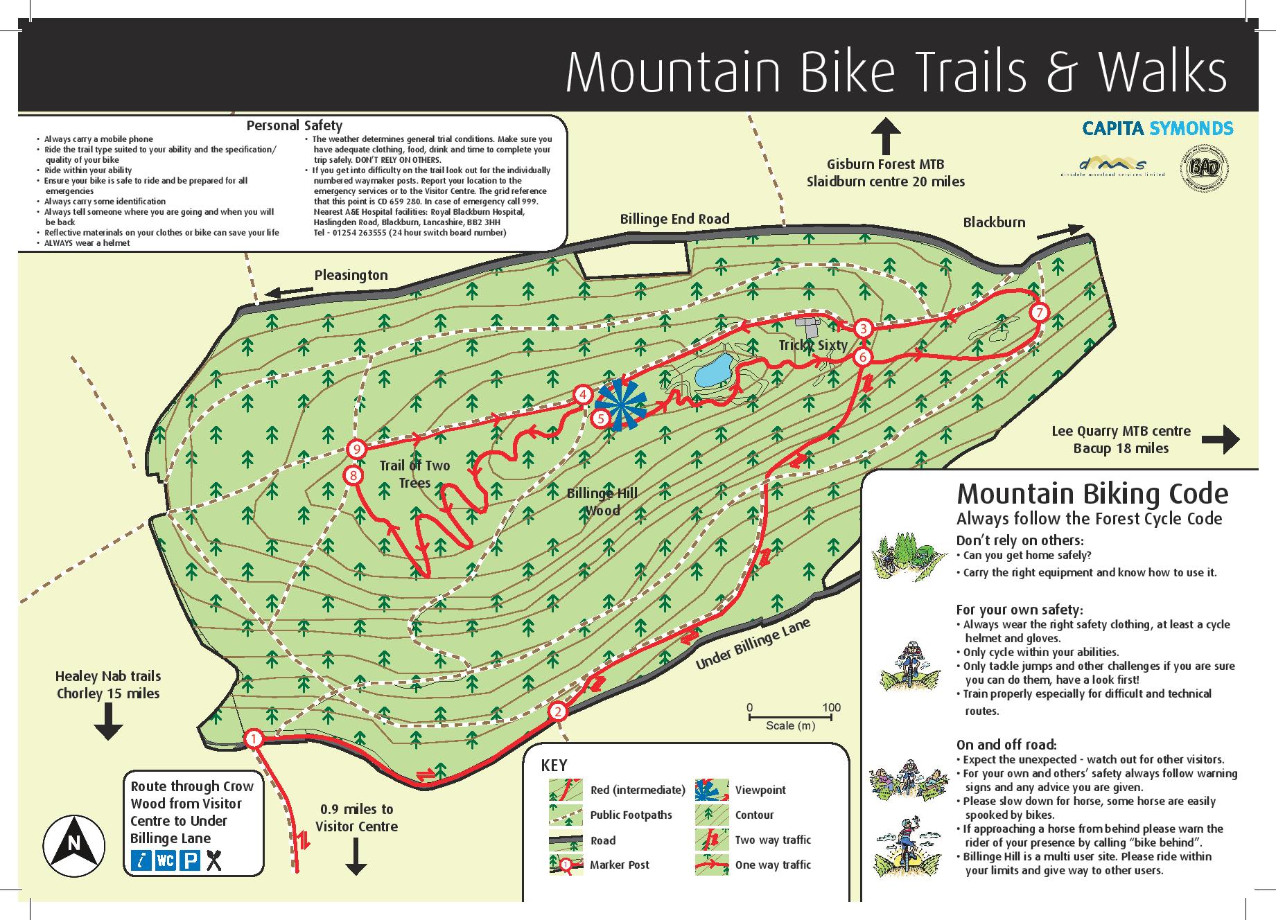
The Trails
Tricky 60 starts from this turret platform and is a short descent towards the NE corner of the woodland. There is not
much pedalling if you don’t wish but the trail swings right and left the whole descent. There is only one access trail to
cross where horses may be encountered but the trail layout has been so designed so as to enable user groups to observe
each other before actually coming together. Please be considerate. Whilst generally rated a red grading there are black
rated alternative routes which can be integrated utilising rock formations to the side and cascades. A little bit of
something for everyone here. At the bottom, it’s possible to take the lower bridleway back to Crow Wood or take the
trail left back to the trail head. Both trails are cycle only trails and unidirectional –_downwards.
The Two Trees trail is about 25 yards away to the right from the trail head if looking towards Blackburn. Blackburn and
District Mountainbikers (BAD) have erected high signs to direct first time visitors. As the name of the trail suggests it is
more of a woodland trail with woodland features notably two sections where the narrowly boarded trail rises over a
horizontal branch. There are side trails around these features.. In several places the trail passes over a large rock with
the brief possibility to get some air between tyres and ground. Still in general a downhill route more pedal power is
needed here as the trail swoops left and right through the trees. At the bottom of the trail a sometimes challenging
path can be followed back to the right towards the trailhead.
The resulting trails have stood the test of time and enjoyed by the majority of visitor riders. Some of the features have
become eroded but the only maintenance has been to remove leaves in the autumn, to clear and fill puddles and now
after about 4 years resurfacing would be beneficial so some of the original features might be re-sculpted otherwise they
serve the intended purpose.
Further Development
Of course the trails do not suit and satisfy all riders nor all needs and further side trails and direct down trails for those
so inclined are often tried. However, modification to the present trails are not encouraged as they were fully risk
assessed, and short cutting and downhill trails do adversely affect erosion. There are some interesting developments
though, including the extension of the Witton Weavers Way and other links that might benefit the cross country rider.
The hope is that a network of ring circuits can be established for riders to give mountainbiking a try from Witton Park,
first passing around the perimeter track, then maybe progressing to the new pump track by the Pavillion, to
circumnavigate the perimeter of Witton park, progressing to Billinge Hill and then maybe progressing to Pleasington and
beyond. Thus progressing from 2m to 4, 8 and 12 miles from the cars.
The Pump Track.
A new tarmac covered pump track has been installed near to the pavilion in Witton park
References:
Billinge History
http://www.british-history.ac.uk/vch/lancs/vol4/pp83-87
Billinge brochure and further descriptives
https://www.blackburn.gov.uk/Pages/Billinge-Woods-mountain-bike-trails.aspx
http://www.visitblackburn.co.uk/dbimgs/Billinge%20Hill%20and%20Pleasington%20cycle%20route%20map.pdf
Pump track LET article